
(incomplete, last edits Dec. 31)
Visual Sources

The immediate base surroundings is sometimes called the Yarmouk area of the district named Salaheddin or a couple of variations, or alternately Khalet/Khelet/Khalid/Khalida Ferjan/al-Ferjan/Forjan. Arabic for the last: خلة فرجان.

Rebels "storming" the base well-after it had been taken, from the look of it. Shows the north area, main gate, and a bit of the interior.
A drive-by video from May, when the large warehouse-type buildings at the south end of the base at least were already bomb-damaged.
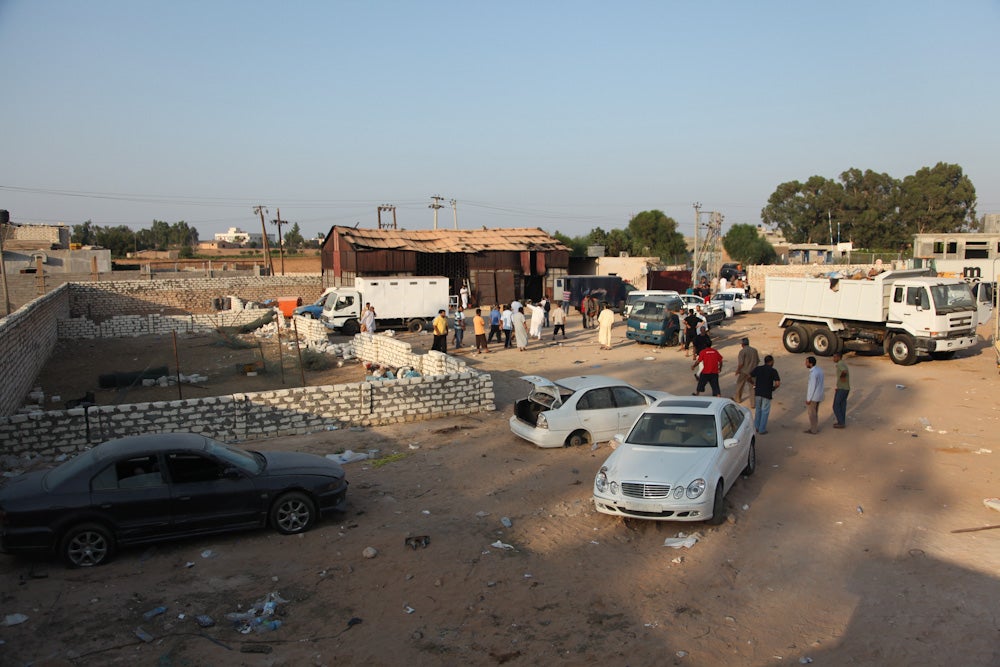
CBC video shows some glimpses of bomb-gutted buildings inside, as seen at right, as well as the shed yard in the adjacent area.
Al Jazeera video of the shed yard, with a nice full-circle pan.
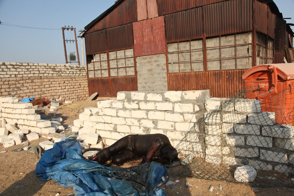
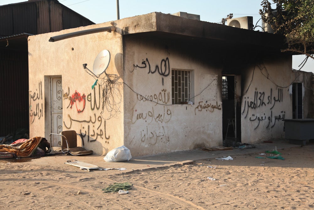
Human Rights Watch photos, from this useful report on their silly "investigation," show the shed yard (see map below) from three views (using afternoon light presumptions): looking north from atop the trashed truck perhaps, looking northeast from just west of the shed (includes a dead body), and looking northwest from the gate area - one of the mattress victims is visible.
Conformity with Satellite Imagery

It took me a while to locate another fit, not far away to the northeast. Diagonally across the patch of 15 giant "crop circles," one kilometer east of the top row, at the curve in al Hadhbah Road, is a perfect match. It's got the right cross-roads, matching double-pillar gate structure, wall dipping further from the road to the south, covered walkway things out front to the north, built-up interior and - are my eyes deceiving me, or does the current Google maps imagery show extensive bombing damage within the compound?
Google maps link
 I didn't yet spot the shed area, where the massacre was allegedly staged. But all reports say it's adjacent to, adjoining, or perhaps even within this eagle-gate place, so it should be nearby. I'll leave that puzzle to readers for now. The grounds will look kind of like this, presuming afternoon light in general, with exact north orientation uncertain-it could be rotated a bit from this in reality. The bodies probably won't be shown - this is just to make this graphic dual-use, helping clarify where the dead outside the shed were.
Update Nov. 22: Contributor Petri Krohn found it right behind the base. He looked for peaked roofs like the shed has. Since most buildings there have flat roofs, this was smart, and helped narrow down a great match.

And then a graphic of the whole area base area and where it is.As an afterthought, I added a small orange square in the lower left corner where Wikimapia had placed the Yarmouk base.
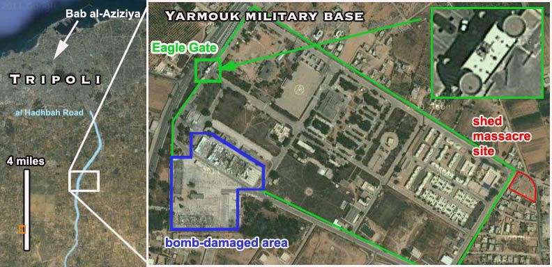
The apparent bomb damage, highlighted here in blue and worth a closer look, is largely to the base's south side. The warehouse buildings with their sheet metal blown all over, and a few concrete buildings closer to the center, can be seen in some of the video views at top. Some of this is months-old already as the base was finally taken. More extreme building damage, cropped off here, is apparently outside the compound, southeast of the highlighted area here. There are other spots with craters in the ground, buildings with holes in the roofs and/or debris blown out across streets, throughout the compound. It's possible what was there in late August was more bombed yet, but the large building in the dirt lot near the north corner at least seems to be intact.
As far as we know, there have been no reports or evidence of dead soldiers anywhere in there. Only 150 or so of their random captives, all collected at that red corner compound and mostly burned to anonymity.
Almost all buildings in the neighborhood, like most of Libya, have flat roofs. I find three sheds with "northern" V-shaped roofs. Could be this one:
ReplyDeletehttp://g.co/maps/c29ae
Yeah, hey, that's a possible fit, and adjoining. I'm sure I saw that last night, but it wasn't clicking. I'll double-check later, but I suspect I'll be saying good call.
ReplyDeleteBrilliant work, Petri. I wonder what was in the rubbish bin (orange) also visible on the satellite pic, perhaps, next to the broken wall.
ReplyDeleteJamel Essedini reported for Euronews from the battle zone of Yarmouk,:مراسل اليورو نيوز من جبهة... showing cases of ammunition being plundered, uploaded on August 26 by euronewsar, although one doesn't see the main entrance.
ReplyDelete(Euronews translates as Feed in Google!) with further footage from inside a building with Italian voice over, Essedini reporting again.Tripoli: scoperti arsenali nei quartieri civili , August 28 by euronewsit.
Earlier I commented on a The Telegraph video from August 25 showing a bomb-damaged shelter holding a large number of mainly undamaged T-55 tanks. The video claims to be form Mitiga airbase. I could not find the shed there.
ReplyDeleteLibya rebels discover Gaddafi's huge tank store in Tripoli ready for battle
Uploaded by telegraphtv on Aug 25, 2011
http://www.youtube.com/watch?v=xJ3A4LqjJqo
The shed similar in construction to the bombed-out sheds on the south-eastern corner of the base, but I could not find a match.
It is only now the I notice that there is another barracks complex around 1km south of the base on the main road. Further south there are storage sheds on both sides of the road. The tank shed on the western side is similar to the tank shed on the video, but the surroundings do not match.
It is only now
There is a new photo on Panoramio from November 4, 2011 showing the shed complex from the outside.
ReplyDeletehttp://www.panoramio.com/photo/61674659
There are some others near by, but they may be misplaced.
Correction: the Panoramio photo shows the wall on the other side of the road looking north and electricity pylon in front of the gate.
ReplyDeleteI am reposting this here, as this is the correct spot for this information. I should have done this already long ago.
ReplyDeleteThere are in fact three distinct "Khamis Brigade" bases in the Saleheddin area.
There is a large barracks compound with bombed out warehouses 1 km south of the eagle gate base, further down the al Hadhbad Road.
http://g.co/maps/vrbu2
There is a large arms depot with a small barracks building half way between the al Hadhbad Road and the Airport Road. It is located just north of the north-east corner of the large "crop circle" fields. This location is about 1,5 km east-northeast of the eagle gate.
http://g.co/maps/8yc74
I believe this is the arms dump taken over by rebels on August 26th and shown in this photo.
I've been meaning to mention my inability to place the Euronews Aug. 26 front line video within the main Yarmouk compound. I really can't find it. (graphic attempts available upon request) This might help, but I'm still not seeing it readily. I've noticed the bombing to the south, yeah, about a km. I think I checked there...
DeleteAnyway, thanks for putting these things together. quite helpful. The compound between the roads might be significant. An indoor photo doesn't help much. Is this the same place Majid was freaking out at?
"The complex of mustard-walled buildings had its walls holed by bombs, its roofs caved in and windows blasted open."
DeleteI didn't notice any bombed-looking buildings in that area.